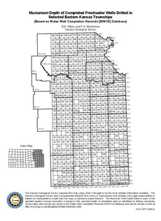
This open file report shows a map developed by the Kansas Geological Survey for the Kansas Coporation Commission.
 |
|
 The
Kansas Geological Survey made a conscientious effort to ensure the accuracy
of this report. However, the Kansas Geological Survey does not guarantee this
document to be completely free from errors or inaccuracies and disclaims any
responsibility or liability for interpretations based on data used in the production
of this document or decisions based thereon. This report is intended to make
results of research available at the earliest possible date, but is not intended
to constitute final or formal publication.
The
Kansas Geological Survey made a conscientious effort to ensure the accuracy
of this report. However, the Kansas Geological Survey does not guarantee this
document to be completely free from errors or inaccuracies and disclaims any
responsibility or liability for interpretations based on data used in the production
of this document or decisions based thereon. This report is intended to make
results of research available at the earliest possible date, but is not intended
to constitute final or formal publication.