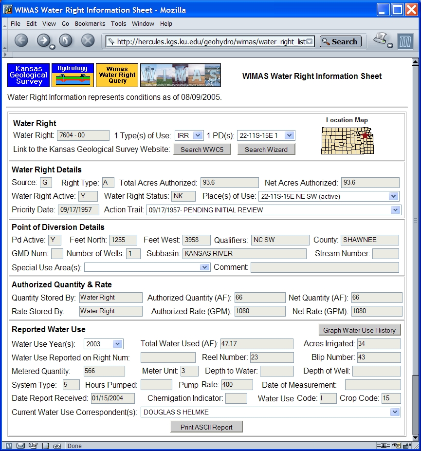
Water Information Management and Analysis System,
Version 5, for the Web. User Manual


http://hercules.kgs.ku.edu/geohydro/wimas/index.cfm


WIMAS version 5 for the Web was funded in part by the State Water Plan Fund of the Kansas Water Office and the Kansas GIS Policy Board.


Open-file Report No. 2005-30
October, 2005


Brownie Wilson1, Jeremy Bartley1, Kelly Emmons2, Jim Bagley2, Jim Wason2, Steve Stankiewicz2

1Kansas Geological Survey, University of Kansas, 1930 Constant Avenue, Lawrence, KS 66047
http://www.kgs.ku.edu

2Division of Water Resources, Kansas Department of Agriculture, 109 SW 9th Street, Topeka, KS 66612
http://www.ksda.gov/Default.aspx?tabid=173

The Kansas Geological Survey and Division of Water Resources do not guarantee this document to be free from errors or inaccuracies and disclaims any responsibility of liability for interpretations based on data used in the production of this document or decisions based thereon.


Table of Contents

Disclaimer
Introduction
Internet Browser Requirements
Accessing WIMAS 5
Query Setup
Query Results
Water Right Information Sheet
Point of Diversion Information Sheet
Summarize Quantity
Water Use Trends
Development Trends
Download Data
Create Map
Conclusions
References
Appendix A- Codes

Disclaimer

The Kansas Department of Agriculture, Division of Water Resources (KDA- DWR), and the Kansas Geological Survey (KGS) exercise great care in the administration of the Water Information Management and Analysis System (WIMAS) program. However, neither the KDA-DWR nor the KGS offers a warranty or guarantee of the accuracy or completeness of the WIMAS program and the data contained therein. The KDA-DWR nor the KGS assume no liability for errors in, interpretation of, or use of these data.

Water rights are dynamic and often complex entities. The water rights data used in WIMAS represent the water rights files as of a specific date. A new water rights data set for the WIMAS program is generated nightly.

Information provided in WIMAS cannot be used to determine whether a water right has been lawfully used in accordance with the terms, conditions, and limitations specified in the vested right, certificate, or permit. To obtain current standing information on a particular water right file, please contact the KDA-DWR.

The term "status", as used in the WIMAS program, denotes one of the following phases of a water right´s development: (1) The application is pending initial review by the KDA-DWR; (2) a permit has been issued; (3) the KDA-DWR has received a notice and proof of completion of the diversion works; (4) the time to perfect the water right has expired; (5) a Certificate of Appropriation has been issued; or (6) the water right has been dismissed for some reason.

Information contained in the WIMAS program is a public record; however, by accessing the WIMAS program, associated data, and any products generated by WIMAS (i.e. maps, graphs, tables, and reports) the user agrees that they will not use them for selling, or offering the sale, of any property or services in violation of K.S.A 45-220(c)(2).

For more information, contact the KDA-DWR by phone at (785) 296-3710 or via the Internet at http://www.ksda.gov/Default.aspx?tabid=261.


Introduction

Water rights in the State of Kansas are complex and dynamic entities that permit their owners the privilege of appropriating water for beneficial use. The amount of information collected on water rights is extensive and increases each year. The Kansas Department of Agriculture, Division of Water Resources (KDA-DWR), currently maintains an Oracle-based RDBMS called the Water Rights Information System (WRIS). The WRIS contains over 70 relational tables that store data on points of diversion (e.g. ground-water wells and surface water intakes), place of use, authorized quantity and rate allocations, historic reported water usage, and a host of other parameters. The ability to extract out information from the WRIS data system requires a strong working knowledge of not only the water rights data themselves, but the business rules, table structures, and underlying relationships of the WRIS.

To facilitate data analysis, open-records requests, and water-resource decision making, the KDA-DWR and the U.S. Geological Survey (USGS) developed in 1991 a GIS-based application known as the Water Information Management and Analysis System (WIMAS). WIMAS was first written within the Environmental System Research Institute´s (ESRI) ARC/INFO program that ran in a UNIX, X-Windows environment (Juracek, 1992). By integrating data sets from both the KDA-DWR and the USGS, WIMAS allowed users the ability to analyze the availability and use made of water in a spatial context. WIMAS was the first GIS application to both map and simplify the intricacies of queries to the KDA-DWR water rights data. However, its use outside of the cooperating agencies was minimal. Users were required to have access to a UNIX workstation running a licensed copy of ARC/INFO.

In 1994, the KDA-DWR decided to migrate its water rights information from a mainframe based, SUPRA database, to the WRIS. The water rights database was restructured to represent a true, relational database model. As such, the water rights database was no longer in a format compatible with the UNIX WIMAS GIS application. The KDA-DWR database migration combined with an increase in the numbers of ESRI´s pc-based ArcView software users, the Kansas GIS Policy Board provided funds to rewrite and enhance the functionality of WIMAS to run as an ArcView application (Wilson, 1998). This 4th iteration of WIMAS was provided as both a customized ArcView project file and an ArcView software extension. It allowed users to download new water rights data that was updated weekly from the Data Access and Support Center, the State´s repository of GIS data.

WIMAS for ArcView has a larger user base than its UNIX predecessor; however, it still has limitations. It requires a licensed copy of the ArcView software, stores only a single year of historic reported water use data, and needs a minimum of 100 mb of drive space to access the supporting GIS data layers that are stored locally on the user´s computer. In 2004, the Kansas Geological Survey (KGS) and the KDA-DWR were awarded funding through the Kansas GIS Policy Board from the State Water Plan Fund to migrate the core functionality of WIMAS to an Internet-based application, referred to as WIMAS version 5 for the Web (WIMAS 5).

This web-based version of WIMAS allows, for the first time, true public access to water rights data. The advantages of this type of application environment are numerous. Users of WIMAS 5 are no longer required to purchase specialized software. All that is needed is internet access and a standard web browser. The web site is powered by Macromedia´s ColdFusion and ESRI´s ArcIMS internet software. This allows all the retrieval and processing of the water rights data to occur on the web server itself. This means even the most basic computer internet connection (i.e., dial up versus DSL) will operate with the same speed and capability.

Data access by WIMAS 5 covers a much broader range of time periods and topics. This includes access to the entire history of reported water use and spatial mapping of authorized irrigated acreage, both of which are unavailable in the older versions of the program. It has a broad range of selection options to query water rights and a host of tools and functions that summarize both current and past water usage. Data accessed by WIMAS 5 is updated nightly from the KDA-DWR WRIS system.

Information access by WIMAS 5 is public record. However, user should be aware of several issues. This program cannot be used to determine if a water right is in good standing with its terms and conditions. It can also not be used for selling, offering of sales, and other marketing activities that are in violation of K.S.A. 45-220(c)(2).

The WRIS data accessed by WIMAS represent one of the most comprehensive data sets for water rights in the United States. However, like all database systems, it is a representation of reality and thus will always contain some level of error. For example, these errors may be blatant (i.e. a typo), occur in the manner of how the data model is structured, be introduced by the methods of data collection, or be found in its use such as implying a false level of accuracy to a subject matter that has an inherent level of uncertainty.

The data accessed by WIMAS is complex because water rights themselves are complex. The purpose of this report is to outline the functionality of the WIMAS 5 web site and not water rights administration. Users of WIMAS should have at least a basic understanding of the Kansas Water Appropriation Act and how that applies to water rights analyses. The tools and functions described represent conditions as of the date of this report. It is anticipated that new capabilities will be added over time.

Internet Browser Requirements

WIMAS 5 for the Web was developed and tested using Internet Explorer version 6 and Netscape version 7 browsers. The web site uses common, free browser add-ons and mechanics. Specifically, Macromedia´s Flash player, Java scripting, cookies, and pop-ups are all used to navigate, store, and display information. If your browser does not support these options, WIMAS 5 may not operate properly.

Accessing WIMAS 5

The internet URL for WIMAS 5 is http://hercules.kgs.ku.edu/geohydro/wimas. The starting point for every WIMAS session is the disclaimer page. To use WIMAS 5 you must accept the terms and conditions outlined in the disclaimer. The disclaimer page only appears at the start of each session and the other web pages within WIMAS will not open without its acceptance. Once acknowledged, you will not be prompted again until there is a period of inactivity lasting for 30 consecutive minutes or you try to open the WIMAS site with a different browser.

Query Setup Page

The WIMAS query page provides a variety of options and filters to select water rights for analysis. This page will only open after the initial disclaimer has been accepted. Once open, it will be the new starting point for the rest of your WIMAS session when you want to reset a query or direct your browser back to the starting WIMAS URL.


At the top of the page (as well as all preceding WIMAS pages) will be a message indicating the date represented by the water right information you are querying. Data are updated automatically every night from the WRIS. Barring any unforeseen hardware or software failures during the nightly updates, the water rights data used by WIMAS 5 will be the preceding day.

The options for querying and filters are as follows:

Public Land Survey System (PLSS)
The list boxes for township, range, range direction, and section allow you to specify your search by PLSS legal description. Any combination of PLSS parameters can be entered meaning you can enter a single township or go down to the section level.


Geographic Box
The Geographic Box allows you to specify coordinates that outline a study area box to query water rights. The latitude and longitude need to be in decimal degrees based on the North American Datum of 1927 (NAD27).


County(s)
The county list allows you to select one or more Kansas counties. Counties are arranged in the list box in alphabetical order. Holding down the Ctrl button allows you to interactively add and remove counties while holding the Shift button lets you select a block of counties by clicking the top and bottom of the block.


Individual Water Right
Water rights are often referred to in a number of ways with the most common being the "File Number". Since a file number may consist of multiple parts, the combination of Right Type, Vested County Code, Water Right Number, and Water Right Qualifier can be used to identify a specific water right to query. The majority of water rights in Kansas are appropriated water rights and can be referenced simply by entering their number. If the water right has been split for administrative reasons, you can enter the qualifier for the water right in the Water Right Qualifier section. For vested water rights (those that pre-date the 1945 Kansas Water Appropriation Act), you must specify the county the vested right is in. Only vested water rights contain a county designation as part of their file number. Finally, the type of water right can be specified if necessary.


Filter by Use Made of Water and Water Source
You can further customize your query by specifying uses made of water or the source of supply for those water rights. The Filter by Use Made of Water allows you to query for six of the fourteen uses of water. These six uses of water represent the most common types in Kansas. You can also specify your query to only return the source of water supply, that being ground or surface water.

The summary routines used in WIMAS 5 (discussed later in this report) automatically report totals by use made of water and source of water supply. As such, these filters are used primarily to set up specific files for downloading data or specific types of analyses.

Filter for Vested and/or Appropriated Rights
There are several types of water rights in Kansas. By default, WIMAS 5 will filter your query to return only "Vested" or "Appropriated" water rights. If you want to query for the other water right types (i.e. temporary, term, etc.) you will need to turn this filter off.


Email Address
Before a query is executed in WIMAS 5, you are required to enter your email address. This is a requirement of the Kansas Open Records Act and serves as a digital signature for the information you are requesting. Your email address will NOT be made available for public access, sold for marketing programs, or used for solicitations of any kind.


Mapping Page
By setting the check box for the mapping page, the results of your query will be sent directly to the mapping page (discussed later in this report). By default, this option is turned off and your query results are passed to the WIMAS Query Results page (also discussed later) from which you have the option to access the same mapping components of WIMAS 5.


Select Water Right Button
Once you have the parameters of your query set, click on the Select Water Rights button. If you have any problems with your query (such as entering text in a latitude or longitude box) a message will appear listing the problem. You will also be notified if no water rights match your selection criteria.

Query Results

The WIMAS Query Results page shows a list of all the water rights that matched your selection criteria. At the top of the list is a simple message notifying you of how many unique water rights and unique points of diversion have been selected. The selection criteria you specified on the query setup page are listed in the upper left corner of the browser window just under the water right information date notification.


The water rights list can be sorted in ascending or descending order by the water right´s file number, use made of water, use of water active indicator, source, priority date, status, legal description for the points of diversion, longitude, latitude, county, or point of diversion active indicator. For display purposes, only 50 records are shown on your web browser at one time. You can move through these records by clicking on the record range links listed at the top and bottom on the query list. Codes shown in the list, for example the Wr Status can be seen in Appendix A of this report.

A notable complexity with water rights is how they can overlap each other. For example, a single water right may have multiple uses of water and multiple points of water diversion. Likewise, a single point of diversion may be associated with multiple water rights. This many-to-many data relationship will cause some of the information to be replicated in the water rights list, thus causing the actual number of records shown in the list to be greater than the total unique water right and point of diversion counts displayed at the top of the table.

The water right lists will likely contain records that are no longer active as of the date of the query. These inactive records are included primarily because they reference historic reported water usage and past water right development. A water right may be inactive because it was officially dismissed or abandoned (identified by the WR Status) or either its use made of water or point of water diversion is no longer in operation (Use of Water Active and Pdiv Active). These inactive water rights can be removed from the list by clicking on the filter check-box at the upper right of the list.

Water Right Information Sheet

If you click on a hyperlink for a specific water right (Wr File Number) in the list, the WIMAS Water Right Information Sheet will appear in a new browser window. At the top of the page, the water right you selected is shown along with the total number of uses of water and total number of points of diversion it may be associated with. Information shown on this page depends on a water right´s selected use and point of diversion. If there are multiple uses and/or multiple points of diversion, the page will update itself depending on which entry is selected from those list boxes. Points of diversion are displayed by their PLSS legal description plus a sequence number assigned by the KDA-DWR, often referred to as the DWR_ID.


The Water Right Details portion of this page outlines specifics to the water right and use made of water. Of particular importance in this section is if the water right and/or use made of water are active based on the active indicators and status. If the use is irrigation, the total and net acres authorized to be irrigated are listed. The net acres will be equal to or less than the total depending on any limitations associated with the water right, which are usually caused by the water right overlapping another more senior (older) water right by point of diversion and/or place of use. The Action Trail list box will show the administrative history of the water right. The Place(s) of Use list box show the PLSS section where, to the nearest township-range-section water under this right can be applied. For IRR uses, place of use is identified down to the quarter-quarter section level.

The Point of Diversion Details section of the page contains information specific to where water is actually diverted from its original source. The active indicator will show whether or not the point of diversion is currently active along with other spatial characteristics. The comment field can be useful in identifying other information, such as whether or not the point of diversion is part of a battery or the "GeoCenter", which is an artificial point of diversion representing the mean center of the battery.

A water right´s authorized quantity and rate specifies how much water is appropriated annually and how fast that water can be pumped. These have a complexity in that authorized quantities and rates can be assigned to the water right itself, the individual uses made of water, or specific points of diversion. The net values will be equal to or less than the authorized amounts depending on any limitations associated with the water right.

The Reported Water Use section shows the historic self-reported water use records for the water right/use/point of diversion combination. Data related to individual years of water use can be obtained by changing the year listed in the Water Use Year(s) list box. Clicking on the Graph Water Use History button displays a chart of past water usage and the table of data used in the graph. The underlying graph is a jpeg file that can be saved to your hard drive by right mouse clicking on the graph. Your web browser will try to save the graph image with a .CFM extension to the file name. If you change this to .JPG, the file will save properly and the image file can be used in other applications.

At the bottom of the sheet is the Print ASCII Report button. Clicking this option will generate a link to a simple ascii-based file that displays the entire content of the Water Right Information Sheet. This file can be imported into a variety of other software packages such as word processors or ASCII editors like NOTEPAD. This file is useful if you want to copy and paste information from the list boxes such as the Action Trail or Place(s) of Use.

Because water rights can overlap both in points of diversion and places of use (which in turn affects the total authorized quantities and rate) AND water usage is often aggregated into a single report, you cannot determine if a water right has reported more water use than authorized from this page.

Finally if the water right is ground-water based, the PLSS legal description for the point of diversion can be used to search for matching records in the other primary Kansas ground-water well inventories. Clicking the Search WWC5 button will pass the township, range, and section parameters to the Water Well Completion (WWC5) web site. The WWC5 database contains lithologic information on all wells drilled in Kansas (Bureau of Water, 1993). The Search WIZARD button will pass just the township and range to the WIZARD web page. WIZARD (Hausberger et al., 1998) is the repository of depth-to-water data across the state (although heavily focused on the High Plains Aquifer region in western and south-central Kansas). In both cases, the search results return any matching records based on legal descriptions. It is up to users to find a matching well or one to use as a proxy by comparing the specific characteristics of the ground-water well (i.e. well depth, qualifiers, etc.).

Point of Diversion Information Sheet

Clicking on a hyperlink for a specific PDIV Location in the list on the WIMAS Query Results page will bring up the WIMAS Point of Diversion Information Sheet. This sheet contains exactly the same information as the Water Right Information Sheet except it is tied to a specific point of diversion. Since a point of diversion may have multiple water rights which in turn may have multiple uses of water, the sheet will update itself to represent data based on these three parameters.

Summarize Quantity

The Summarize Quantity button, located in the upper left corner on the WIMAS Query Results page, calculates the total amount of water authorized for all uses and the total number of acres authorized for irrigation in your selection set. The WRIS does not store historic authorized allocations so the summary results represent the listed date of the data. The summary is presented in a matrix format that totals the annual allocations by use made of water and source of water supply.


The graph buttons at the bottom of the matrix will show the results by use made of water or source of water supply. Two charts are provided; the first is a bar chart and the second is a pie chart showing the relative proportions. The charts for use made of water will show all the uses as opposed to the matrix which groups several use types into an "Other" category.

Water Use Trends

The Water Use Trends option from the WIMAS Query Results page allows you to review historic reported water use. The actual years available to review depend on your selection set. Water use reports may go back as far as 1958. However, reports were not required to be submitted annually to the KDA-DWR until the mid-1980s. Also, 1990 was the first year that the water use data itself under went a quality control and assurance program administered by the Kansas Water Office and more currently, the KDA-DWR.

The water use page provides a couple of tools to analyze past water usage. Selecting a year and clicking on the Generate Water Use Matrix button creates a summary matrix (exactly the same as the authorized quantity matrix) that summarizes the total amount of water reported used, by source and use made of water. Once the matrix has been created, you can download the individual water use records for the water rights.

The Submit/Download Trend Request button allows you to summarize the total annual amount of reported water used and total number of acres reported irrigated based on a starting and ending year. Once the data have been established, you can download an ASCII comma-delimited file of either the water use data for the individual water rights or the summary totals. Please note that depending on the size of your query, reported water use summaries may take several minutes to setup.


Development Trends

A common water right analysis (that is often done improperly) is to track the development of water rights over time. The Development Trends button will create a graph and a table summary of the total number of water rights and total number of points of diversion over time. You can limit the graph to only active/non dismissed water rights by checking the check box located just above the graph. At the bottom of the table, you have the option to download an ASCII comma-delimited file of the yearly totals.


The number of points of diversion over time does not represent the year a well or surface water intake was actually constructed. Rather, it represents the year the point of diversion was associated with the priority date for a specific water right. If a single point of diversion is associated with multiple water rights, only the priority date for the most senior (oldest) water right is used. Vested water rights, those rights that have been using water for beneficial use since before the 1945 Kansas Water Appropriation Act, are listed as having a date of 1944. Some vested water rights were actually established as far back as the 1800s.

Download Data

Several places within WIMAS 5 allow you to download data depending on the tool or function you have selected. The Download Data button on the WIMAS Query Results page will set up an ASCII comma-delimited file of all the water rights, their uses of water, points of diversion, plus other related information. By right mouse clicking on the file link, you can use your browser to download the data to your hard drive.

Once the download file has been created, you will also be given the option to create a zipped ESRI shapefile suitable for use in WIMAS version 4 for ArcView 3.x. This shapefile will be based only on the water rights from your selection set and should replace the PD shapefile on your hard drive. The PD shapefile for WIMAS version 4 can only store one year of water use data so you must select which year you want to use.

In order to properly replace the PD shapefile used by WIMAS 4 on your hard drive, you first must delete all the files associated with it. The exact number of files can range from three to seven depending on the indexes used by ArcView 3.x. Once all the pd.* files have been deleted from the wimas\covers\ directory, you can right mouse click on the zip file name and save the file to your hard drive OR if you have an un-compression program installed on your computer (like WinZip), left click on the file name to activate the extraction process.

Please note the number of tables and computer processing needed to create this zipped shapefile is extensive and it will take several minutes to generate the file.

Create Map

Like its earlier versions, WIMAS 5 has a mapping component that allows you to view the spatial patterns of water rights development to other map features. Clicking on the Create Map will map the points of diversion from your selection set based on their listed latitude and longitude. In almost all cases, the latitude and longitude values are calculated based on the point of diversion´s legal description.


The mapping page provides you a dynamic map of the water rights and other related features that you can interact with. Points of diversion can be displayed by their associated water right´s use made of water or source of water supply. Map layers can be turned on or off with several of them being scale-dependent meaning they cannot be turned on until you have zoomed in to a specific area extent. To zoom in and out of the map, select a Zoom Level from the list box and click on the map. The greater the zoom level, the more you zoom in or out of the map extent. Several of the map layers will also automatically label their associated map features when you zoom into a certain level. The file number is used to label the points of diversion. Setting the Pan option allows you to center the map based on a point you click with the mouse.

In addition to displaying the points of diversion, you can also plot the authorized acreage for irrigation-based water right´s (place of use). The WRIS stores authorized acreage down to the 40-acre tract level. For example, 25 acres in the SE quarter of the NW quarter of a particular section may be authorized to be irrigated as part of one or more water rights. What you don´t know is where that acreage is spatially located within that quarter quarter of the section. WIMAS 5 plots the irrigated place of use by assigning the quarter quarter tracts as "Whole" or "Partial". A "Whole" classification indicates 40 (or in some cases more than 40) acres are authorized while a "Partial" designation indicates acreage of less than 40 acres.


The Identify PD option allows you to click on a point of diversion from the map and view the relevant information from the WIMAS Point of Diversion Information Sheet. The Print Map button allows you to setup a more printer friendly display of the map results. You have the options to change the map title and include or exclude the date and overview map.

Conclusions

WIMAS 5 for the Web is a web-based application that allows near real-time, public access to Kansas water rights data. Unlike past versions, users are no long required to purchase specialized software. Through an internet browser, users have access to a host of selection options, data parameters, processing tools, mapping capabilities, and downloading choices that will facilitate the analysis and management of the State´s water resources.

From its inception in 1991, the concept of the WIMAS program has been to provide a user interface allowing access and analysis of water rights in the State of Kansas without having a strong working knowledge of the underlying data relationships and structures. As technology and computer processing have advanced, so has WIMAS. WIMAS 5 for the Web represents the latest iteration of this software concept.

References

Bureau of Water, Kansas Department of Health and Environment, 1993, Article 30 Water Well Contractor´s License; Water Well Construction.

Hausberger, G., Davis, J., Miller R., Look, K., Adkins-Heleson, D., Ross, G., Bennet, B., Schloss, J., Bohling, G., 1998, WISARD: Water Information Storage and Retrieval Database, Kansas Geological Survey Open File Report 1998-13.

Juracek, K. E., 1992, Use of a Geographic Information System to Assist with Studies of the Availability and Use of Water in Kansas, U.S. Geological Survey Open-File Report 92-142.

Wilson, B. B., 1998, Water Information Management and Analysis System (WIMAS), ver. 4, for ArcView User´s Manual, Kansas Department of Agriculture, Division of Water Resources.

Appendix A- Selected WRIS Codes

Listed below are the some of the more common code translations used by the KDADWR. Some of these will actually appear on various WIMAS 5 web pages and others will only be available on downloaded files. There are some codes, such as the stream codes, that number in the thousands and are not represented here. For more information, contact the KDA-DWR.

Right Type
A Appropriation
B Basin Term
D Domestic
P Temporary
T Term
V Vested


Active Indicator (Use Made of Water and Pdiv)
Y Active
N Inactive


Use Made of Water
ART Artificial Recharge
CON Contamination Remediation
DEW Dewatering
DOM Domestic
FPR Fire Protection
HYD Hydraulic Dredging
IND Industrial
IRR Irrigation
MUN Municipal
REC Recreation
SED Sediment Storage
STK Stockwater
THX Thermal Exchange
WTR Water Power


Source of Water Supply
S Surface Water
G Ground Water


KDA-DWR Field Office
1 Topeka
2 Stafford
3 Stockton
4 Garden City


Groundwater Management District
1 Western Kansas GMD #1
2 Equus Beds GMD #2
3 Southwest Kansas GMD #3
4 Northwest Kansas GMD #4
5 Big Bend GMD #5


Status
AA Vested Active
AM Dismissed After Vested
AY Pending Initial Review
FO Dismissed Prior to Approval
GA Denied Prior to approval
GM Reinstated Prior to Approval
GY Approved Pending Completion
HK Extended Time to Complete
HW Dismissed Pending Completion
II Reinstated Pending Completion
IU Partial Completion
JG Partial Completion - Extended Time to Complete
JM Inspected Prior to Completion
KE Completed Pending Inspection
KK Completed - Extended Time to Perfect
KQ Dismissed Pending Inspection
LC Reinstated Pending inspection
LG Completed - Partial inspection
LK Partial Inspection Extended Time to Perfect
LO Inspected Pending Perfection
LR Inspected Pending Perfection - Extended Time to Perfect
LU Dismissed Pending Perfection
LZ Reinstated Pending Perfection
MM Proposed Certificate
MR Proposed Certificate - Extended Time to Perfect
NK Certificated Issued
NQ Dismissed After Certificated Issued
NT Reinstated After Certificate Issued
NV Reinstated After Vested


Basin
1 Missouri River
2 S F Big Nemaha River
3 Marais Des Cygnes River
4 Sugar Creek
5 Pottawatomie Creek
6 Little Osage River
7 Marmaton River
8 Kansas River
9 Stranger Creek
10 Wakarusa River
11 Delaware River
12 Vermillion Creek
13 Big Blue River
14 Black Vermillion River
15 Little Blue River
16 Mill Creek
17 Smoky Hill River
18 Saline River
19 Big Creek
20 Hackberry Creek
21 Ladder Creek
22 N F Smoky Hill River
23 Solomon River
24 Salt Creek
25 S F Solomon River
26 N F Solomon River
27 Republican River
28 Prairie Dog Creek
29 Sappa Creek
30 Beaver Creek
31 S F Republican River
32 Arikaree River
33 Arkansas River
34 Neosho River
35 Spring River
36 Cottonwood River
37 Verdigris River
38 Caney River
39 Elk River
40 Fall River
41 Cimarron River
42 Bluff Creek (cimarron)
43 Crooked Creek
44 N F Cimarron River
45 Bear Creek
46 Salt Fork Arkansas River
47 Medicine Lodge River
48 Chikaskia River
49 Bluff Creek (chikaskia)
50 Sandy Creek
51 Walnut River
52 Ninnescah River
53 N F Ninnescah River
54 S F Ninnescah River
55 Little Arkansas River
56 Cow Creek
57 Rattlesnake Creek
58 Walnut Creek
59 Pawnee River
60 Buckner Creek
61 Whitewoman Creek
62 Driftwood Creek


Special Use Area
001 RRC-Arikaree R
002 RRC-S F Republican R
003 RRC-Beaver C
004 RRC-Sappa C
005 RRC-Prairie Dog C
006 RRC-Main Stem Republican R
007 SS-N FK Above Kirwin
008 SS-Bow Creek
009 SS-S FK Above Webster
010 SS-N FK Below Kirwin
011 SS-S FK Below Webster
012 SS-Solomon R Below Waconda
013 Burrton (IGUCA)
014 Smoky H R PIGUCA (AB Cedar Bluff)
015 Smoky Hill IGUCA
016 Ark River (IGUCA)
017 Hackberry Creek (PIGUCA)
018 McPherson (IGUCA)
019 Hays (PIGUCA)
020 Pawnee (IGUCA)
021 Amazon Ditch (Ark River)
022 Farmers Ditch (Ark River)
023 Frontier Ditch (Ark River)
024 Garden City Ditch (Ark River)
025 Great Eastern Ditch (Ark River)
026 South Side Ditch (Ark River)
027 Farmers-Great Eastern (Ark River)
028 Amazon-Great Eastern (Ark River)
029 Special Water Quality Use Area
030 Alamo-FT Aubrey (Ark River)
031 Alamo Canal (Ark River)
032 FT Aubrey Ditch (Ark River)
033 Walnut Creek (IGUCA)
034 Effective Alluvial
035 Upper Republican Connection
036 Upper Republican Contributing


System Code (Water Use Data)
1 Flood
2 Trickle-drip
3 Center pivot
4 Center pivot LEPA
5 Sprinkler other than center pivot
6 Center pivot and flood
7 Subsurface drip (SDI) in combination with other type
8 Other
9 Center Pivot with Mobile Drip


Meter Units
1 or G Gallons
2 or A Acre-Feet
3 or I Acre-Inches
4 or B Barrels
5 or C Cubic Feet
6 or T Reported Meter Malfunctioned
7 or Z Inadequate Information
8 or Q Calculated But Not a Metered Amount
9 or H Hour Meter


Crop Codes
1 Alfalfa
2 Corn
3 Grain Sorghum
4 Soybeans
5 Wheat
6 Oats
7 Barley
8 Rye
9 Dry Beans
10 Sunflowers
11 Golf Course
12 Truck Farm
13 Orchard
14 Nursery
15 Other
16a/ More than one type of crop
17 Double Crop
18 Alfalfa & Corn
19 Alfalfa & Grain Sorghum
20 Alfalfa & Soybeans
21 Alfalfa & Wheat
22 Alfalfa & other
23 Corn & Grain Sorghum
24 Corn & Soybeans
25 Corn & Wheat
26 Corn & Other
27 Grain Sorghum & Soybeans
28 Grain Sorghum & Wheat
29 Grain Sorghum & Other
30 Soybeans & Wheat
31 Soybeans & Other
32 Wheat & Other
33 Alfalfa, Corn & Grain Sorghum
34 Alfalfa, Corn & Soybeans
35 Alfalfa, Corn & Wheat
36 Alfalfa, Corn & Other
37 Alfalfa, Grain Sorghum & Soybeans
38 Alfalfa, Grain Sorghum & Wheat
39 Alfalfa, Grain Sorghum & Other
40 Alfalfa, Soybeans & Wheat
41 Alfalfa, Soybeans & Other
42 Alfalfa, Wheat & Other
43 Corn, Grain Sorghum & Soybeans
44 Corn, Grain Sorghum & Wheat
45 Corn, Grain Sorghum & Other
46 Corn, Soybeans & Wheat
47 Corn, Soybeans & Other
48 Corn, Wheat & Other
49 Grain Sorghum, Soybeans & Wheat
50 Grain Sorghum, Soybeans & Other
51 Grain Sorghum, Wheat & Other
52 Soybeans, Wheat & Other
53 Alfalfa, Corn, Grain Sorghum & Soybeans
54 Alfalfa, Corn, Grain Sorghum & Wheat
55 Alfalfa, Corn, Grain Sorghum & Other
56 Alfalfa, Corn, Soybeans & Wheat
57 Alfalfa, Corn, Soybeans & Other
58 Alfalfa, Corn, Wheat & Other
59 Alfalfa, Grain Sorghum, Soybeans & Wheat
60 Alfalfa, Grain Sorghum, Soybeans & Other
61 Alfalfa, Grain Sorghum, Wheat & Other
62 Alfalfa, Soybeans, Wheat & Other
63 Corn, Grain Sorghum, Soybeans & Wheat
64 Corn, Grain Sorghum, Soybeans & Other
65 Corn, Grain Sorghum, Wheat & Other
66 Corn, Soybeans, Wheat & Other
67 Grain Sorghum, Soybeans, Wheat & Other
68 Alfalfa, Corn, Grain Sorghum, Soybeans
69 Alfalfa, Corn, Grain Sorghum, Wheat
70 Alfalfa, Corn, Grain Sorghum Wheat & Other
71 Alfalfa, Corn, Soybeans, Wheat & Other
72 Alfalfa, Grain Sorghum, Soybeans, Wheat & Other
73 Corn, Grain Sorghum, Soybeans, Wheat & Other
74 Alfalfa, Corn, Grain Sorghum, Soybeans, Wheat & Other
75 Pasture
76 Sod/Turf Grass
77 Cotton
78 Grapes


Water User Report Codes
1** Report received with no beneficial use indicated. See Code H.
2* Report received with no beneficial use indicated. See Code H.
3 Report received with no beneficial use indicated, without a reason for non-use given on report form.
  Example - "No water used this year".
4* Report received with no beneficial use indicated. See Code J.
5 Report received, no beneficial use reported and no comments made.
  Example: the form is blank or the metered quantity column is blank, or the hours column is blank. Information is not supplied to obtain a quantity of water.
6* Report received with no beneficial use indicated. See Code 5.
A or 7 Metered quantity of acre-feet.
B* Report received but unacceptable for recording.
C Report received for 2 or more P/D´s or file numbers showing metered quantity, hour or rates reported together.
D File dismissed by action of the Chief Engineer.
E Report received: Non-use with a reason. Reason may satisfy KAR 5-7-1 for non-use. A history of this code will require further review to maintain if good cause exists for non-use.
  Explanation: The reason given for non-use on the report as received may satisfy K.A.R. 5-7-1 for non-use at face value. Three (3) successive years of this same code will require further review to determine if in fact good cause exists for non-use.
  Examples: Weather - adequate rainfall; enough rain; wet year; abundant rainfall; sufficient rainfall; rainfall.
  Management - summer fallow; fallow operation; pastured cattle (stockwatering); no water sold; demand for water reduced this year.
  Water Supply - no water available for surface sources; creek dry; used water from an irrigation district; used another source (river or reservoir water); no water flow; dry (surface water); insufficient water supply (surface source).
F Water use data obtained from field inspection report. A reel and blip number 99-9999 is entered into the computer for these reports.
G Report received - Use with hours of pump operation or hours and pump rate. A quantity of water can be determined by report content.
H Report received: Possible satisfactory reason for non-use, with reservation
  Explanation: The reason for non-use on the report may appear at face value to satisfy K.A.R. 5-7-1 for non-use for one (1) to two (2) years. But, were such reason to be repeated over three (3) successive years, the file should be reviewed in depth to determine if the reason for non-use constitutes due and sufficient cause.
  Examples: "well caved in", "bankruptcy", "not enough water" (groundwater sources), "pump broke down", "planted to wheat", "dryland", "pumping sand", pending Water Rights Conservation Program.
I Report in metered quantity of acre-inches (computer converts to acre-feet)
J Report received: Possible non-satisfactory reason for non-use
  Explanation: The reason given for non-use on the report appears unlikely to satisfy K.A.R. 5-7-1. If this reason is repeated for three (3) successive years the file should be reviewed in depth to confirm reasons for non-use.
  Examples: "Economic reasons", "high fuel cost", "choose not to irrigate".
K Report received: Government programs except CRP
  Explanation: Reduced use of water because of annual enrollment in any governmental program, except CRP, which does not require use of water as a condition of enrollment.
  Examples: "ASCS Farm Program", "ACR Acres", "Governmental set-aside", "0-92" option, any mention of enrollment in a government program. I.e. "acreage allotment".
L Report received: Conservation Reserve Program (CRP)
  Explanation: Reduced us of water because of enrollment in the federal government´s CRP, which does not require use of water as a condition of enrollment. This code should not be utilized unless a CRP contract or other proof of enrollment has been received. If no CRP contract is provided, use Code "J".
  Examples: Enrollment in "CRP".
M or 8 Meter quantity in gallons
9 Domestic and recreational. If metered quantity or hours and rate are not provided, and the only information given on the report is the persons in the household, acres of garden, number of livestock, or lake levels then the report is coded a 9.
N Report received: Point of diversion reported to be out of service.
  Explanation: The reason given indicates the point of diversion authorized is permanently out of service. Follow-up should be done to confirm this. A "closure/dismissal" or verified report may be necessary.
  Examples: "sold pump", "plugged/caved in", "abandoned", "not in service", "anticipated future use", "remove from mailing list".
P Report received: Administrative review
  Explanation: Information on the report suggests that files should be reviewed by DWR staff for clarification.
  Example: "well replaced", "stream bank caved, moved downstream", "different well", "plan to reactivate", "seasonal flooding", "not purchased a pump".
O Overlapping number
Q Report received: Water quality impairment
  Explanation: Non-use was reported for reasons of water quality deterioration by outside influence.
  Example: "VOC´s", "brime spills", "oil", or "other petroleum spills", "high nitrates", "salt".
R Report received: Repetitive reporting
  Explanation: If the reason given for non-use is repeated for three (3) or more years this code will be assigned and the file will subsequently be reviewed by the Division of Water Resources´ staff. Said review may lead to a closure/dismissal or verified report.
  Examples: The following reasons repeated for three (3) successive years: "economic conditions", "same number of hours, quantity, etc.", "adequate or excessive rainfall".
S Report received and subsequently returned for clarification or additional information.
T Meter trouble.
U Report returned by U.S. Post Office as undeliverable.
V A point of diversion not completed during notice of completion ending date.
W Water Rights Conservation Program Plan approved.
X Report received indicating an ownership change.
Y Indicates a reporting problem. Requires further administrative review by staff.
Z For years prior to 1989. Energy reported only.


Quantity and Rate Storage Indicators
1 Stored by Water Right
2 Stored by Point of Diversion
3 Stored by Use Made of Water