To view the images at varying levels of resolutions, click on the links below. More recent browser will let you zoom in and out of the images based on the size of your browser window and the pixel size (resolution) of the images.
Right mouse click on the link and select "Save Link to Disk" or "Save Link Target As" from the pop-up menu to save the file to your hard drive. On Macintosh computers, hold your mouse button down and a pop-up menu should appear.
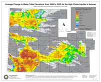
Average Change in Water Table Elevations from 2000 to 2005 for the High Plains Aquifer in Kansas
Page Size: 42 x 34 inches.
Low Resolution : 96 Dots Per Inch (DPI), 4.36 mb JPEG
High Resolution (PDF): 1.96 mb PDF
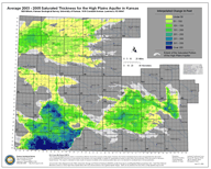
Average 2003-2005 Saturated Thickness for the High Plains Aquifer in Kansas
Page Size: 20 x 16 inches.
Low Resolution : 96 Dots Per Inch (DPI), 1.69 mb JPEG
High Resolution (PDF): 1.75 mb PDF
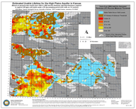
Estimated Usable Lifetime for the High Plains Aquifer in Kansas (based on ground-water trends from 1996 to 2000)
Page Size: 20 x 16 inches.
Low Resolution : 96 Dots Per Inch (DPI), 1.76 mb JPEG
High Resolution (PDF): 1.6 mb PDF
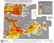
Estimated Usable Lifetime for the High Plains Aquifer in Kansas (based on ground-water trends from 2000 to 2005)
Page Size: 20 x 16 inches.
Low Resolution : 96 Dots Per Inch (DPI), 1.79 mb JPEG
High Resolution (PDF): 1.67 mb PDF
 The
Kansas Geological Survey made a conscientious effort to ensure the accuracy
of this report. However, the Kansas Geological Survey does not guarantee this
document to be completely free from errors or inaccuracies and disclaims any
responsibility or liability for interpretations based on data used in the production
of this document or decisions based thereon. This report is intended to make
results of research available at the earliest possible date, but is not intended
to constitute final or formal publication.