Water Level Measurements

391053096260901
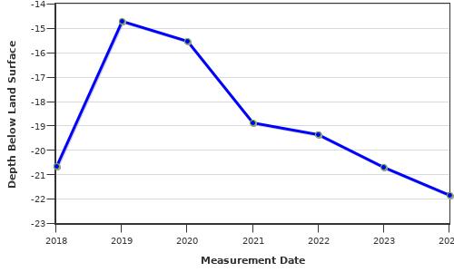
Note that depth to water is feet below land surface and all measurements for the well are included.
Hydrograph- Annual Average Depth to Water Below Land Surface
|
| Date | Depth to Water | Status | Agency | Method |
WL Source | Tape Hold | Chalk Cut | Initials |
| AUG-15-2018 | -20.64 | - | KGS | Electronic-Tape | - | - | --- | ECR |
| AUG-19-2019 | -15.02 | - | KGS | Electronic-Tape | - | - | --- | ECR |
| SEP-10-2019 | -14.35 | - | KGS | Electronic-Tape | - | - | --- | SJK |
| MAR-11-2020 | -15.58 | - | KGS | Electronic-Tape | - | - | --- | ECR |
| JUN-25-2020 | -14.89 | - | KGS | Electronic-Tape | - | - | --- | ECR |
| AUG-04-2020 | -15.38 | - | KGS | Electronic-Tape | - | - | --- | ECR |
| AUG-11-2020 | -15.43 | - | KGS | Electronic-Tape | - | - | --- | ECR |
| OCT-06-2020 | -16.3 | - | KGS | Electronic-Tape | - | - | --- | ECR |
| SEP-29-2021 | -18.69 | - | KGS | Electronic-Tape | - | - | --- | ECR |
| DEC-03-2021 | -19.03 | - | KGS | Electronic-Tape | - | - | --- | ECR |
| JAN-13-2022 | -19.29 | - | KGS | Electronic-Tape | - | - | --- | ECR |
| FEB-01-2022 | -19.24 | - | KGS | Electronic-Tape | - | - | --- | ECR |
| MAR-09-2022 | -19.43 | - | KGS | Electronic-Tape | - | - | --- | ECR |
| OCT-31-2022 | -19.3 | - | KGS | Electronic-Tape | - | - | --- | ECR |
| FEB-21-2023 | -20.14 | - | KGS | Electronic-Tape | - | - | --- | ECR |
| JUL-18-2023 | -20.7 | - | KGS | Electronic-Tape | - | - | --- | ECR |
| NOV-06-2023 | -21.17 | - | KGS | Electronic-Tape | - | - | --- | ECR |
| FEB-01-2024 | -21.65 | - | KGS | Electronic-Tape | - | - | --- | ECR |
| JUN-26-2024 | -21.98 | - | KGS | Electronic-Tape | - | - | --- | ECR |